Kiama storms — what a show, right? They bring some of the most jaw-dropping natural displays you’ll find Down Under. Picture this: towering waves crashing like they’re in a boxing match with the shore, with lightning flickering like it’s got a vendetta. Seriously, it’s nature’s own fireworks, and it’s all visible from the coastline.
Now, if you’re at Ridgewaters Kiama, you’re not just watching — you’re experiencing it. We give residents front-row seats to these wild weather spectacles… from the cosy, safe haven of our elevated balconies. The oceanfront apartments? They offer killer views of those beastly storm systems rolling in, all while you kick back at a safe distance from the potentially dicey surf. No need to dive headfirst into the chaos — enjoy the drama from afar like it’s your personal theatre.
What Makes Kiama Perfect for Storm Watching
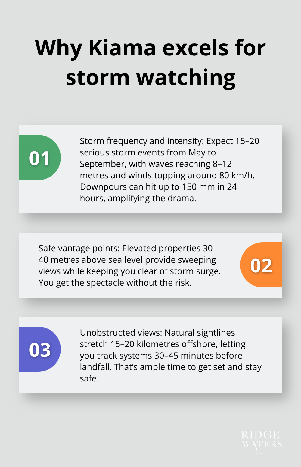
Kiama-where the Southern Ocean crashes into the NSW coastline-it’s a natural amphitheatre for Australia’s wildest weather spectacles. Picture this: 15-20 serious storm events yearly, from May to September, when those low-pressure systems go on a southeast joyride from the Tasman Sea. It’s where waves at nearby Bombo Headland surge to 8-12 metres, and winds frequently hit the 80 km/h mark during peak bashings. Per the Bureau of Meteorology-yes, real data, folks-coastal areas here get drenched with above-average rainfall in these stormy times, with downpours smacking up to 150mm in just 24 hours.
That’s wet.
Prime Elevation for Safe Storm Observation
Here’s the kicker-Kiama’s lofty coastal terrain. It’s your VIP seat to the storm show without the muddy risks. Properties chilling 30-40 metres above sea level give you a clear view of nature’s chaos while keeping you safe from storm surge tantrums. Watching those 10-metre waves slam the coast? Piece of cake. No worries ’bout ocean spray reaching your heights. The National Weather Service politely nudges folks to stay 100 metres inland during feisty coast storms, but with those sky-high apartments, you’re good to safely peep from way closer.
Unobstructed Pacific Views
It’s simple geometry, really. Kiama’s natural design offers majestic sightlines-15-20 kilometres out to the sea-so you can follow storm systems as they creep in. The coastline here does this gentle curve that provides sweeping views from Bombo Beach right up to the Kiama Blowhole-zero skyscrapers barging in. Spotting storm fronts 30-45 minutes before they hit land? Not too shabby. Enough time to cosy up with some hot java and watch Mother Nature’s drama club. No pesky tall buildings or headlands to cramp your eastern view, making Kiama far more suited for storm spotting than Sydney’s northern beaches.
Optimal Weather Patterns
Here’s the science bit-the region’s microclimate ramps up storm action with what’s called orographic lift. That’s when air loaded with moisture stacks up against the coastal escarpment, creating more epic clouds and upping the drenching compared to the run-of-the-mill flat areas. Local winds? They funnel storms straight for Kiama’s charming beaches, with southeasterly swells swaggering in with maximum oomph and spectacle.
Once you’re dialed in on why Kiama’s the storm-watching HQ, the next move? Timing. You’ll want to snag those primo observation slots for max excitement-minus the drama.
When Should You Watch Storms in Kiama
Alright, so storm season in Kiama slams in hard from May through September. Picture this: late June to early August is the golden ticket. That’s when those southeasterly swells put on a show that’ll make you gasp. Imagine low-pressure systems cruising in from the Southern Ocean shaking hands with cooler ocean surfaces, and boom! You’ve got a recipe for brewing awesome waves and lightning spectaculars. Oh, and water temps? They drop to 16-18°C, cranking up that storm-making machine even more.
Peak Storm Windows
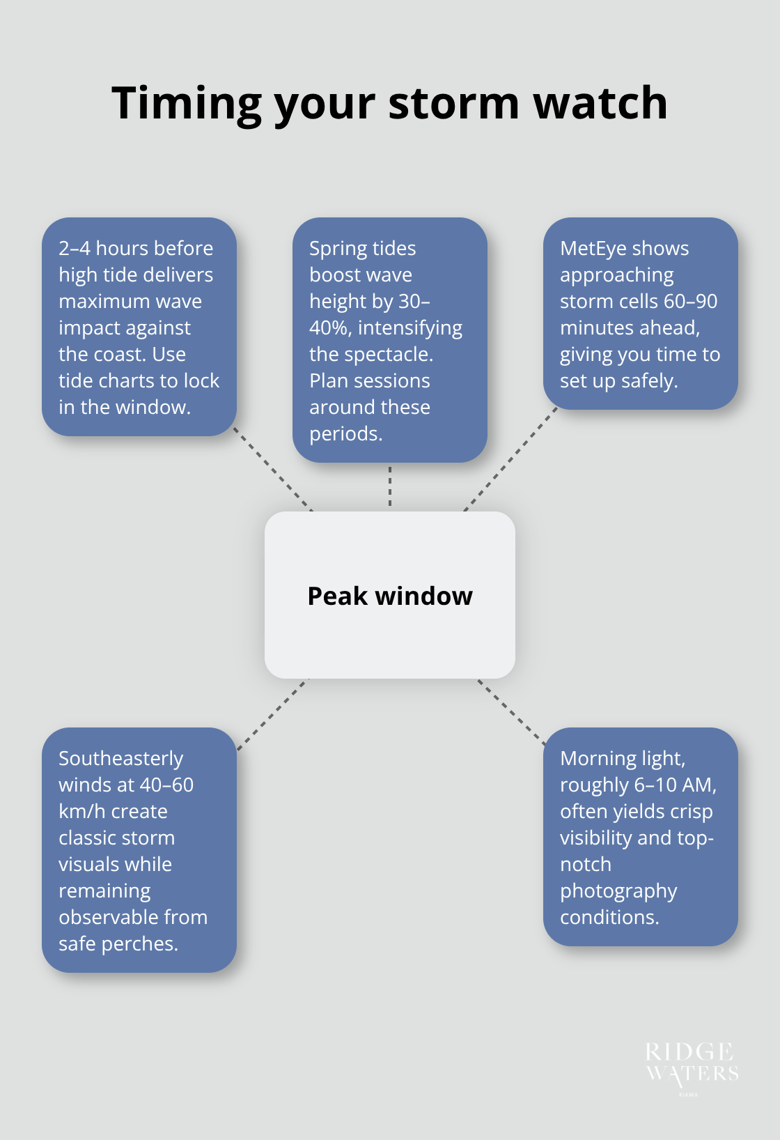
Timing, folks, timing. You want to catch the magic 2-4 hours before high tide – think max wave action slamming against Kiama’s rugged coastline. Tide charts? Your new bible. Why? Because during spring tides, waves get a 30-40% boost, height-wise. Apps like Bureau of Meteorology’s MetEye – these are your crystal balls showing storm cells 60-90 minutes before they crash the party. Winds at 40-60 km/h from the southeast? They make for postcard-perfect scenes. Mornings, say 6-10 AM, often deliver those crisp, clear shots photographers die for.
Weather Pattern Recognition
Now, if that barometric pressure drops below 1010 hPa, you know a big storm’s drawing near (you’re looking at a 12-18 hour heads-up). Scout the skies – when those cumulonimbus clouds start towering over 8,000 metres, grab that rainjacket. And when the winds shift from northeast to southeast? That’s your cue: the storm’s flexing its muscles. A quick temp drop of 5-8°C in just half an hour? Yeah, things are about to get wild. These natural hints are your personal storm-sensors before the official word gets out.
Safety Protocol During Severe Weather
Listen up – when those winds hit 63 km/h or the waves start towering over 6 metres, that’s serious stuff, and it’s a regular affair in Kiama. Best bet? Stay tucked away inside until winds chill out below 50 km/h. Data shows most who get caught outside are in the storm’s opening act, underestimating Mother Nature’s punch. A no-go zone is any rocky coast or beach when swells are over 4 metres – even seasoned locals steer clear of Bombo Headland then. Prep like a pro: keep a battery-powered radio, torch, and at least three days’ worth of water handy, because power blackouts love to strike during peak storm season.
Got the storm schedule down? Great. Now it’s time to kit out your balcony for a front-row, safe and comfy storm-watching gig.
How Do You Prep Your Balcony for Epic Storm Views
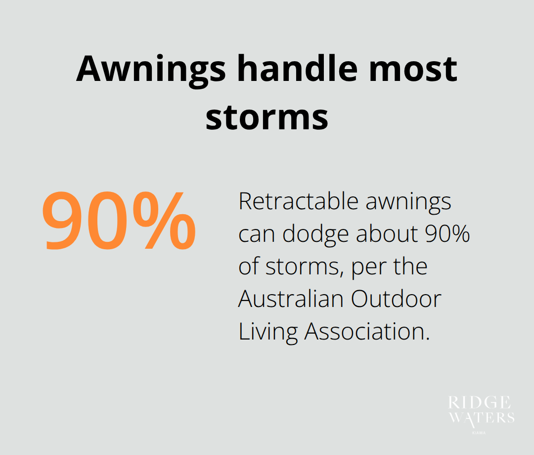
Let’s get real-storm season is not for the faint of heart, especially when your balcony is a wind hit parade. First things first, you gotta batten down the hatches, which means turn anything light into a human-proof dented object before May crashes the party. Kiama winds? They’re no joke and could launch a rogue chair like a torpedo. So, double down-strap those chairs with 15kg sandbags or just usher them inside. Glass-tops? Swap them out for buff metal tables that laugh in the face of wind. Speaking of which, retractable awnings over fixed umbrellas all day, every day-they’re storm ninjas, dodging that whopping 90% of storms efficiently, as per our mates at the Australian Outdoor Living Association. Got cushions? Store them.
Waterproof boxes are your new best friends. Keep them snug against your apartment’s wall to avoid the whirlwind.
Essential Storm Watching Kit
Brace yourself-storms in Kiama aren’t casual. They slash temperatures by about 5-8°C faster than you can say “where’s my thermal blanket?” So, layer up. A thermos bubbling with hot drinks isn’t optional here-think of it as a cosy lifeline over the next 2-4 stormy hours. Power out? Happens almost half the time, so LED lanterns with 12+ hours of juice are your beacon of hope. And guess what, horizontal rains are a thing here, spurred by those stubborn southeasterly swells, so waterproof your phone. And hey, when Wi-Fi taps out, a little weather radio plays saviour with its constant updates from Bureau of Meteorology.
Camera Setup for Storm Photography
Storm photography isn’t just a click-fest; it’s an artful dance with Mother Nature. You need ISO 100-200, paired with 8-15 second exposures-that’s how you snag those epic lightning streaks. Anything less? You’re looking at a lacklustre sky. Your camera? Needs to be rock-steady, anchored on a beefed-up tripod set a good 2 metres away from your balcony’s edge. Why? Because water spray equals no bueno. Chase those pre-storm clouds-I’m talking 30-45 minutes before the storm’s at its zenith-to catch those theatrics in the sky. Lightning? Every 3-5 seconds, giving you a plethora of money shots. And, obviously, a 70-200mm telephoto lens, because we’re not about getting soaked, thanks very much.
Post-Storm Equipment Care
Post-storm cleanup isn’t trivial. Lens filters? Clean them pronto. Salt spray has zero chill and will ruin glass swiftly. Metal furniture needs a gentle rinse to avoid rust claiming it. And check your anchors-they might’ve loosened their grip in all the chaos. Drain water from boxes, air dry those cushions, and seal any cracks like your gear’s life depends on it-because it does.
Final Thoughts
Picture this: You’re storm watching from your balcony at Ridgewaters Kiama-where wild weather turns into your own suspenseful flick, all from a safe perch. But hey, let’s not get ahead of ourselves… respecting Mother Nature is crucial. Keep indoors when the wind starts howling above 63 km/h or when the waves climb over 6 metres. Lay in supplies like you’re prepping for a season finale, and stick to those Bureau of Meteorology bulletins like your life depends on it (because it might).
At Ridgewaters Kiama, we don’t just offer apartments; we hand you the complete coastal experience wrapped with a bow. Those 15-20 Kiama storms a year? Yep, they transform into blockbusters screened right from your elevated apartment-safely above that pesky storm surge zone. It’s the ultimate in safety meeting thrill… your drama unfolds with front-row views.
Coastal property values, especially those with built-in storm-watching perks, are riding high across Australia. We’re talking oceanfront listings that attract top dollar, particularly when perched a snug 30-40 metres above sea level (a common sight in developments around here). Whether you’re dreaming of a full-time sea view or eyeing rental dough, Ridgewaters Kiama slides you straight into this spectacular show. The ability to storm-watch? Oh, it tacks on tangible value to any coastal property investment. Embrace the tempest… from the safety of your home.